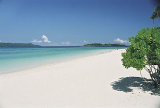
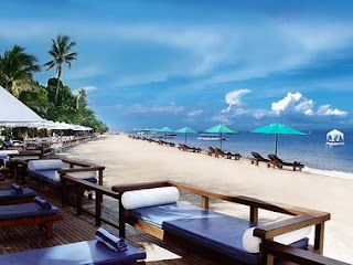
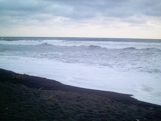
SENGGIGI BEACH
Senggigi, named after a princess in local legend, is the main tourist center in Lombok and the most developed tourist area. The resort area about 10 Kilometers north of Ampenan, and about 20 minutes drive from the Lombok international Airport. Nowhere near as large or as busy as its Bali conterparts, Senggigi is
a great base for exploring the rest of the island. The pace is very laid back, with activities centered around the beaches and day trips to places of interest, which are all with in ferw hours drive from the town. At night dine in the many restaurants catering to all tastest and budgets, listen the live music at the cafes or Bars or dance the night away at the night clubs.
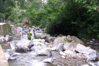
Senggigi is the large bay that forms the center of Senggigi, with the main road running parrarel to the beach, and large resorts occupying the space between. The beach provides picturesque views of Bali's Agung Mountain to the west and stunning sunsets with the volacano silhouetted on the horizon. Senggigi reef, off the Senggigi Beach hotel has good coral for snorkelling and in the right conditions, some decent surf breaks.
The main road in Senggigi is lined with small shops, Restaurants, Bars, Travel agencies and Night Clubs. There are couple of supermarkets, numerous ATM's and Money Changers, Post office and all as ussual tourist facilities. Senggigi is a relaxing place to stay, with a good range of luxury hotels and resorts, as well as mid range and budget accommodations.
The Art Market Senggigi, is located between the Santosa Villas & Resort and Sheraton Hotel. There are numerous small stalls selling handicrafts and souvenirs from aroun Lombok, as well as T-shirts, sarongs and clothing similar to Bali's markets. On the beach, line up restaurants and cafes are nice place to catch the ocean breezes during the day, orr to dine at night watching the lights of the fisihing boats accross the ocean.
How to Get to Senggigi
There is a few alternatives to get to Senggigi Resort
* Coming from Lembar Harbor, you can go straight to Senggigi by Shuttle Bus or Taxi available on call for 24 hours.
* If you are coming by Plane, ask for Airport Taxi services, they will drive you to the hotel as your destination.
* Public transportation or Bemos are available from 06 am to 05 pm.
Stay at Senggigi
There are various range of hotels that you can choose to stay at Senggigi, From Deluxe five star Hotel resort to simple home stays, such as Senggigi Beach Hotel, Purimas Boutique Hotel and Resort, Intan Lombok Village Hotel and Resort, Sheraton Hotel and Resort, Pool Villa, Raja’s Bungalow, Ellen Hotel, Ray Hotel, Senggigi Reef Resort, Bukit Senggigi Cottage, Holiday Resort Lombok, and many more, for details infromation about the Senggigi accommodations please click Senggigi Hotels List.
Dinning and Entertainment
There is various Restaurant and Café to choose at the town of Senggigi Such as, Happy Café with there famous Live band at night, Papaya Café with Live Music, Bumbu Café, Marina Café with Live music, Sunshine Restaurant, Naga Restaurant, Taman Restaurant, and etc. these Restaurant served a selection food from Indonesia cuisine to International cuisine.
What to Do & See
* Swimming off the beach is safe.
* Canoe hire is available on the Senggigi beach.
* Surfing
* Wind Surfing
* Snorkeling
* Take a walk to Batu Bolong Temple (Hollow Rock Temple)
* Sunset
* Water Sport ( Jet Ski, Paraglaiding/Parasailing, and Banana boat)
Read More..
|


Puncak Suroloyo juga menyimpan mitos. Puncak ini diyakini sebagai kiblat pancering bumi (pusat dari empat penjuru) di tanah Jawa. Masyarakat setempat percaya bahwa puncak ini adalah pertemuan dua garis yang ditarik dari utara ke selatan dan dari arah barat ke timur Pulau Jawa. Dengan mitos, sejarah beserta pemandangan alamnya, tentu tempat ini sangat tepat untuk dikunjungi pada hari pertama di tahun baru.
Dikala kepenatan selama satu minggu dengan rutinitas yang melelahkan.minggu pagi yang cerah mentari dari ufuk timur senantiasa menyinari seluruh bumi.ayampun tak kalah dengan gagahnya mengeluarkan suar lantang....,pagi itu kami berenacana untuk adventure untuk menghilangkan penat.setelah kmi berkumpul maka tujuanya adalah sebuah tempat wisata alami yang penuh dengan tantangan.tempat wisata tujuan kami adalah puncak suroloyo.konon puncak ini merupakan puncak tertinggi yang ada di bukit mnoreh,dimana bukit menoreh terletak di kabupaten kulonprogo,DI.Yogyakarta.dimana dari puncak suroloyo kita dapat menikmati pemandangan
yang menajubkan.ternyata itu semua bukan isapan jempol belaka. Puncak Suroloyo, buykit tertinggi di Pegunungan Menoreh yang berada pada 1.091 meter di atas permukaan laut. Untuk menikmatinya, anda harus melewati jalan berkelok tajam serta menakhlukkan tanjakan yang cukup curam, dan memulai perjalanan setidaknya pada pukul 2 dini hari. Dua jalur bisa dipilih, pertama rute Jalan Godean - Sentolo - Kalibawang dan kedua rute Jalan Magelang - Pasar Muntilan - Kalibawang. Rute pertama lebih baik dipilih karena akan membawa anda lebih cepat sampai. Tentu anda mesti berada dalam kondisi fisik prima, demikian juga kendaraan yang mesti berisi bahan bakar penuh serta bila perlu membawa ban cadangan.
Setelah berjalan kurang lebih 40 km, anda akan menemui papan penunjuk ke arah Sendang Sono. Anda bisa berbelok ke kiri untuk menuju Puncak Suroloyo, namun disarankan anda berjalan terus dahulu sejauh 500 meter hingga menemui pertigaan kecil dan berbelok ke kiri karena jalannya lebih halus. Dari situ, anda masih harus menanjak lagi sejauh 15 km untuk menuju Puncak Suroloyo. Sebuah perjalanan yang melelahkan memang, namun terbayar dengan keindahan pemandangan yang dapat dilihat.
Pertanda anda telah sampai di bukit Suroloyo adalah terlihatnya tiga buah gardu pandang yang juga dikenal dengan istilah pertapaan, yang masing-masing bernama Suroloyo, Sariloyo dan Kaendran. Suroloyo adalah pertapaan yang pertama kali dijumpai, bisa dijangkau dengan berjalan kaki menaiki 286 anak tangga dengan kemiringan 300 - 600. Dari puncak, anda bisa melihat Candi Borobudur dengan lebih jelas, Gunung Merapi dan Merbabu, serta pemandangan kota Magelang bila kabut tak menutupi.
Pertapaan Suroloyo merupakan yang paling legendaris. Menurut cerita, di pertapaan inilah Raden Mas Rangsang yang kemudian bergelar Sultan Agung Hanyokrokusumo bertapa untuk menjalankan wangsit yang datang padanya. Dalam kitab Cabolek karya Ngabehi Yosodipuro yang ditulis pada abad 18, Sultan Agung mendapat dua wangsit, pertama bahwa ia akan menjadi penguasa tanah Jawa sehingga mendorongnya berjalan ke arah barat Kotagede hingga sampai di Pegunungan Menoreh, keduia bahwa ia harus melakuykan tapa kesatrian agar bisa menjadi penguasa.
Menuju pertapaan lain, anda akan melihat pemandangan yang berbeda pula. Di puncak Sariloyo yang terletak 200 meter barat pertapaan Suroloyo, anda akan melihat Gunung Sumbing dan Sindoro dengan lebih jelas. Sebelum mencapai pertapaan itu, anda bisa melihat tugu pembatas propinsi DIY dengan Jawa Tengah yang berdiri di tanah datar Tegal Kepanasan. Dari pertapaan Sariloyo, bila berjalan 250 meter dan naik ke pertapaan Kaendran, anda akan dapat melihat pemandangan kota Kulon Progo dan keindahan panati Glagah.
Usai melihat pemandangan di ketiga pertapaan, anda bisa berkeliling wilayah Puncak Suroloyo dan melihat aktivitas penduduk di pagi hari. Biasanya, mulai sekitar pukul 5 pagi penduduk sudah berangkat ke sawah sambil menghisap rokok linting. Bila anda berjalan di dekat para penduduk itu, aroma sedap kemenyan akan menyapa indra penciuman sebab kebanyakan pria yang merokok mencampur tembakau linting dengan kemenyan untuk menyedapkan aroma.
Selain memiliki pemandangan yang mengagumkan, Puncak Suroloyo juga menyimpan mitos. Puncak ini diyakini sebagai kiblat pancering bumi (pusat dari empat penjuru) di tanah Jawa. Masyarakat setempat percaya bahwa puncak ini adalah pertemuan dua garis yang ditarik dari utara ke selatan dan dari arah barat ke timur Pulau Jawa. Dengan mitos, sejarah beserta pemandangan alamnya, tentu tempat ini sangat tepat untuk dikunjungi pada hari pertama di tahun baru.
Read More..
|
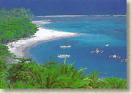
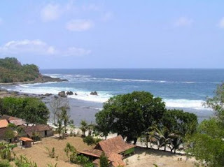
Sanur is one of Bali's biggest traditional villages but it's also one of the most established tourist areas
. Sanur was Bali's first beach resort but still retains its Balinese character and old style village ambiance. On the southeastern side of Bali, Sanur beach is easily reachable from Denpasar, about a 5 to 10 minute drive. Sanur is an excellent site to watch the sun rises, as we jog along the white sandy beach. Being one of the first resorts developed in Bali, Sanur maintains its traditions. Only a stone thrown away from the beach, ancient temples stand as solemn as they have been in centuries past.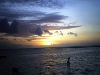
Palm-lined beach, facing the Indian Ocean towards the east, Sanur is an excellent place to see the sun rise in the morning. "Bali is the morning of the world", it is the right sentence for Bali if we has visited Sanur. Offshore reefs protect the beach against the waves, and make it popular for windsurfing, boating, and other water sports. It is one of the first areas where one can find good hotels, restaurants, shops, and other tourist facilities.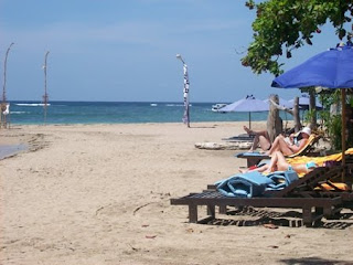
Read More..
|

Once a lonely little village on the road from Denpasar to Bukit Peninsula,
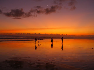
Kuta is now the tourist Mecca of Bali, popular mainly among the young and adventurous. Kuta beach is one of the first favorite beaches discovered by tourist. Coconut trees line the sand beach as far as the eyes can see towards the north stopped by the runway of Denpasar's airport far in the west. The sunset in Kuta is most breathtaking. On the south, the beach is fenced by the airport's runway, which gives the visitors a breathtaking landing experience. Kuta Beach bustles with tourists' vendors and locals. It's the most popular beach in Bali and the island's number one party zone. The beach stretches as far north as the eyes can see. As short walk away north, the waves will invite to surfing. Rapid development and an influx of visitors haven't kept the surfers away and Kuta still remains one of Bali's best surfing beaches and a great place to enjoy a beach lifestyle.
Read More..
|

Jl. Ngasem
Yogyakarta, Indonesia
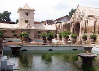
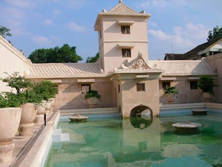
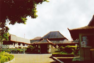
A water garden that was built in 1758 and remains a dynamic and traditional neighborhood.
Tamansari, which means "perfumed garden," is home to some 2,700 residents, a community that distinguishes itself through its craft traditions in batik and traditional painting. The "perfumed garden" is experiencing a revival, becoming a venue for the performing arts, tourism, crafts, and festivals, all of which have improved appreciation for the site.
What Makes Tamansari Water Castle a Great Place?
Tamansari is a popular tourist destination in Yogyakarta, because of its convenient location to the city center and Pasar Ngasem (Ngasem Marketplace). The only way to get around Tamansari is by walking, which makes the place more enjoyable and gives more opportunities to enjoy the various tropical vegetations, local community houses, and batik galleries.
Tamansari is a witness of yesterday's charm in the midst of today's creative life. The ruin is well maintained, and the houses are clean, since the site is a tourist destination. The neighborhood residents take care of the place as well as maintain the safety and cleanliness of the place.
As a visitor, there are so many options, from taking the tour of the used-to-be garden, to visiting local artists’ galleries. Visitors can enjoy the city's view on top of the location, and can visit Pasar Ngasem at the end of the journey.
People around Tamansari are helpful and friendly, they are accustomed to visitors and tourists. The local pride can be seen through their daily life and through the galleries. Ratio of local visitors and tourists: 40:60.
History & Background
Tamansari was built in 1758 as a pleasure palace complex for Sultan Hamengku Buwono I of the Kingdom of Yogyakarta. The 59-building compound included a mosque, meditation chambers, swimming pools, and a series of 18 water gardens and pavilions surrounded by ornamental lakes. The palace complex fell out of use following an earthquake in 1867, which destroyed several buildings and drained the famous water features. Over time, squatters began to inhabit the site, living among the deserted pavilions and building homes in the former lakebeds.
Read More..
|
Kota Gede, which is often called Sargede is located about five kilometers southeast of Yogyakarta,
Kotagede is a neat little town, which was once the seat of the mighty Mataram Empire. Since the 1930s, Kotagede has become famous for being the center of the Yogya silverwork industry. There are a number of workshops where visitors are welcome to watch silver being transformed into beautiful works of art known as "Yogya Silver". Kotagede is easily reached by "andong", the four-wheeled horse-drawn cart, by taxi, bus, or car.
In that cemetery complex one can still visit the cemetery of the Mataram kings like Sutowijoyo or Ngabei Loring Pasar, the founder of Mataram Kingdom, who was then called Panembahan Senopati. There is also the unique tomb of Ki Ageng Mangir. He was Panembahan Senopati son in law and also Panembahan Senopati enemy. His dead body was buried half inside of the special area for kings and Panembahan Senopati families, and a half of his body was buried outside of the complex. There is a stone called " Watu Gilang ", a stone on which Panembahan Senopati smashed the Ki Ageng Mangir head to dead.
Read More..
|
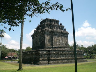
Mendut Temple is the older temple than Borobudur Temple.
There are stories for children on its walls. It is located 1 km to the east of Pawon temple. There are magnificent statues of Buddha inside the temples. For Waisak ceremony, the offering and the praying start in this temple.
Mendut Temple is frequently used to celebrate the Waisak day every May full moon and the pilgrims from Indonesia and all parts of the world come to this ceremony. Its architecture is square, and have an entrance on its steps. Its roof is also square and terraced. There are stupas (= bell-shaped structures) on it.
Read More..
|
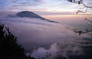
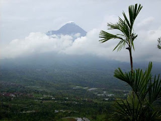
Merapi volcano is one of the world's most active and dangerous volcanoes. It contains an active lava dome, which regularly produces pyroclastic flows. It has been active for 10,000 years.
This fire mountain remains one of the most active and dangerous volcanoes in the world. It can be seen from its name; Merapi from Javanese word 'Meru' means 'Mountain' and 'Api' means 'fire'. The internally giant smoking Mount Merapi is one of the active volcanoes that found in Indonesia. It is presenting its peaceful and sleepy dense forest.
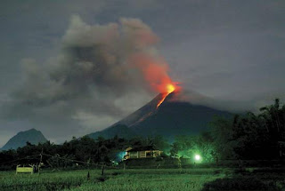
Beyond this, there lies a vast deserted land with its deep and steep valley spread out among the mountain hills where sibilant pines and wild grass make out the dominating vegetation, all presents a very exciting panorama. Merapi is located about 30 km north of Yogyakarta, a city with a population of 500,000. It is tall (2.8 km or 1.7 miles high) and has steep slopes. The top of the volcano sometimes has a normal crater, but usually a broad mound of pasty lava (called a dome) fills the crater. The dome plugs up the volcano, making it difficult for other lava and ash to escape. A broad gouge funnels lava and ash flows from the top of Merapi to the south slopes of the volcano.
Read More..
|

Tawangmangu is located 40 km east of Solo, this recreational resort offers fresh weather; scenic views, swimming pools, bungalow style hotels and restaurants. Tawangmangu,
a mountain resorts at an elevation of almost 1 km above sea level, which promises a cool escape from the city's heat. It lies on the slopes of Mt., Lawu, at an elevation of 1300 m above sea level. A cool splendid hill resort also on the slope of mount Lawu, at about 1400 M height above sea level. The road from Solo via Karangpandan is a fine trip thru magnificent green terraced hills. Tawangmangu has all kind of facilities, hotel, camping ground, forest tourism, etc. The climate is fresh and one can enjoy the beautiful scenery. Other features include nearby temples, a national park and 40m in high waterfall of Grojogan Sewu.
It is a 100 M high waterfall; the pool at the bottom has very chilly water. In front of the gate to Grojogan Sewu, horses for rent are available to ride around Tawangmangu.
Read More..
|
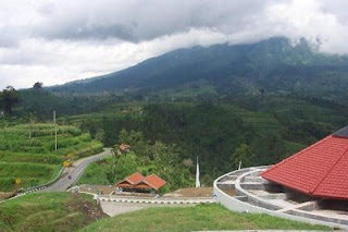
Ketep Pass atau Bukit Ketep, berada pada ketinggian 1.200 dpI dengan luas area sekitar 8.000 m2
. Terletak di Desa Ketep, Kecamatan Sawangan jalur Solo-Selo-Borobudur, sekitar 21 km dari Kota Mungkid , 17 Km dan Desa Blabak ke arah timur, 30 Km dari Kota Magelang, 35 Km dari Kota Boyolali dan 32 km dari Kota Salatiga melalui Kopeng. Dari gardu pandang ini wisatawan bisa melihat pemandangan Gunung Merapi, Merbabu, Sumbing, Sindoro, Tidar, Andong dan Pengunungan Menoreh serta hamparan lahan pertanian. Dan tempat ini bisa melihat luncunan lahar panas Gunung Merapi.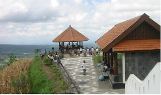
Atas prakarsa Gubernur Jawa Tengah H. Mardlyanto, dipilih tanah berbukit mi untuk dikembangkan sebagal tempat tujuan wisata baru di jalur Solo - Selo - Borobudur dengan Girl khas wisata kegunungapian Ketika diresmikan oleh Presiden RI Megawati pada 17 Oktober 2002 baru dibangun dua gardu pandang dan pelataran. Dengan keunggulan panorama yang atraktif Gn. Merapi - Merbabu, hamparan teras - teras tanah pertanian serta kesejukan udara, Ketep Pass makin ramai dipadati pengunjung, lebih - Iebih pada akhir pekan dan han libur. Awal tahun 2003, dibuka Volcano Theatre sebagam fasilitas baru yang menyajikan film tentang Gunung Merapi dengan berbagai aktifitas vulkaniknya. Fasilitas baru mi makin memperkuat ciri Ketep Pass sebagai tempat wisata kegunungapian. Bangunan ni dilengkapi restaurant yang berada di Iantai atas dengan pemandangan luas ke arah Gunung Merapi.
Kini telah selesai dibangun Volcano Centre. Sebuah bangunan seluas 550 m2 yang menyajikan berbagai materi informasi gunung berapi dengan sajian utama tentang Gunung Merapi. Kehadiran Volcano Centre makin memantapkan karakter khas Ketep Pass sebagai tempatwisata kegunungapian. Memasuki Bangunan Volcano Centre pengunjung akan diajak menjelajahi seluruh ruangan secara mengalir dan sajian materi satu ke yang lain, seolah tanpa putus. Dimulai dan informasi umum tentang gunung berapi dan informasi geologis yang tersaji dalam bentuk gambar, foto dan peta dalam format besar, selanjutnya pengunjung diajak secara interaktif menggali dan menikmati berbagai koleksi gunung berapi melalui perangkat komputer multi media. Contoh batuan yang dilengkapi dengan informasi teknis menjadi sajian berikutnya. Panorama Merapi dalam berbagai tampilan akan mengantar pengunjung pada sajian utama yakni miniatur Merapi dalam ukuran cukup besar. Bagian terakhir sajian adalah Mitigasi Bencana Gunung Berapi yang akan mengajak pengunjung se- cara langsung mengoperasikan peralatan peman tauan dan pende teksian gejala dan kegiatan vulkanik. Cinderamata khas yang hanya di jual di dalam Volcano Centre tersedia di bagian akhir perjalanan pengunjung. Di pintu keluar, melalul trap pengunjung dihantar ke pelataran tertinggi PELATARAN PANCA ARGA, di sini pengunjung dapat menikmati sajian panorama alam lima gunung besar di Jawa Tengah yakni Merapi, Merbabu, Sindoro, Sumbing dan Slamet Selain itu akan nampak pula gunung - gunung kecil lain seperti Telomoyo, Andong, Dataran Tinggi Dieng serta perbukitan Menoreh Bukit Ketep kini telah menjadi tempat tujuan wisata yang menarik dengan ciri khas sajiannya yakni kegunungapian. Atraksi wisata yang tidak hanya bersifat rekreatif tetapi sarat dengan kandungan pendidikan yang tersaji secara atraktit.
Read More..
|
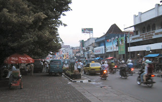
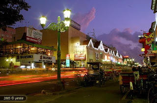
Jalan Malioboro (Malioboro Street) is a major shopping street in Yogyakarta, Indonesia
; the name is also used more generally for the neighborhood around the street. It runs north from the Yogyakarta kraton (palace) towards the roads that lead to either Surakarta to the east, or Magelang to the north, as well as Mount Merapi. This is in itself is significant to many of the local population, the north south orientation between the palace and the volcano being of importance.
The street is the centre of Yogyakarta's largest tourist district; many hotels and restaurants are located nearby. Sidewalks on both sides of the street are crowded with small stalls selling a variety of goods. In the evening several open-air streetside restaurants, called lesehan, operate along the street.
Less obvious to the tourist, but more for the local population, side streets, lanes and structures that lead on to Malioboro are as important as the street itself.
The street was for many years two-way, but by the 1980s had become one way only, from the railway line (where it starts) to the south - to Beringharjo markets, where it ends. The largest, oldest Dutch era hotel, Hotel Garuda, is located on the street's northern end, on the eastern side adjacent to the railway line. It has the former Dutch era Prime Minister's complex, the kepatihan, on the eastern side.
For many years in the 1980s and later, a cigarette advertisement was placed on the first building south of the railway line - or effectively the last building on Malioboro, which advertised Marlboro cigarettes, no doubt appealing to locals and foreigners who would see a pun with name of the street with a foreign product being advertised.
It does not reach the walls or grounds of the Yogyakarta palace, as Malioboro ceases in name adjacent to the very large market Beringharjo (on the eastern side as well). From this point the street changes name and has on the western side the former Governors residence, and on the eastern side the old Dutch Fort Vredenburg.
Read More..
|
SONOBUDOYO MUSEUM
This museum is founded in November 1935 and designed by the Dutch architect Kersten. This Museum is built in traditional Javanese architecture. It
exhibits weapons, leather and wooden puppets of Wayang Theater, masks, statues, textiles, curios and old Javanese gamelan instruments. The museum is situated on the northern side of the city's main square in front of the Sultan's Palace. Sonobudoyo museum is located on the north side of the North Square of Sultan's Palace. 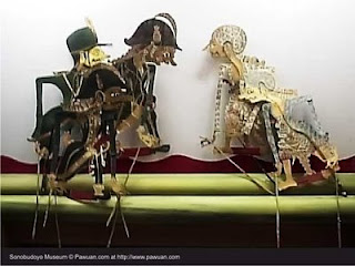
SONOBUDOYO MUSEUMIt was built in 1935 according to Javanese architecture. The architecture of gateway resembles to the entrance of the mosque in Kudus in the way to the auditorium and main Joglo structure, which are connected, while Kudus is the most ancient town in Java Island beside Kotagede. The museum has the second most complete collection of cultural artifacts after the central museum in Jakarta, like ceramic from the Neolithic Age, statues and bronze articles from the 8th, 9th and 10th century originating from Central Java temples, various kinds of masks and wayang (puppet for shadow play), a gamelan or orchestra, an ancient weapon collection, the looms and artifacts from Bali. This museum is also an interesting library that keeps various ancient books related to the Javanese culture.
Read More..
|
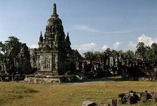
SEWU of THOUSAND TEMPLE
Sewu Temple is located 2 km north of Prambanan Temple. This is the second largest Buddhist Temple complex in Java; Restoration is
professionally underway to reach its original form. It is a MANDALA, manifesting the universe in the center temple of Mahadeva, surrounded by four rings of 250 smaller temples of Gods. Sewu Temple complex is located in Prambanan Temple Park area, about 800 meters to the north of Rara Jongrang Temples. The fact that this temple was built near Prambanan Temple, which is a Hindu temple, indicated that the Hindus and Buddhists lived in harmony.
The main temple has 1 main room and 4 small rooms of which are doorways to the temple. The east door serves as main door to the main room. That way, the main temple faces to the east. The structure has 9 'roofs'; each of them forms a stupa on the top. It is believed to be a royal temple and was one of the religious activity centers in the past. Based on the inscription dated back to 792 AD, which was found in 1960, the name of the temple complex was probably "Manjus'rigrha" (The House of Manjusri). Manjusri is one of Boddhisatva in Buddhist teaching. Sewu Temple was probably built in the 8th century at the end of Rakai Panangkaran administration. Rakai Panangkaran (746 AD - 784 AD) was a popular king from the old Mataram kingdom. HC Cornelius studied the temple firstly in 1807. NJ Krom did the first archeological study in 1923.
Read More..
|

Depok Beach, Enjoy Seafood Cuisine from Fresh Fish
Among other beaches in Yogyakarta, Depok Beach is apparently the only beach that is designed to become the center of culinary tourism to enjoy various seafood menus. Some of the warongs were intentionally designed to face the ocean so that visitors can enjoy the waves rushing to the shore while having delicious meals.
The warongs and the activities of the fishermen have been improving since 10 years ago. The story tells that around 1997 some fishermen from Cilacap area found Depok Beach to be a good place to put their catches ashore. The fishermen with good catches of fish inspired the local people who made their living as farmers to catch fish.
Some people of the coastal community began to become tekong, local term for fishermen. The tekongs go to sea with their motorboats. Catching fish is done almost throughout the year, except certain days that are considered sacred, namely Tuesday and Friday of Kliwon (one of the five Javanese days of the week). The tekongs make good catches except June to September when fish are rare.
With such big quantity of catches, local people opened a center for fish landing that later was completed with a center for fish trading called Mina Bahari 45. Fishermen from other areas can even sell their catches there. When YogYES paid a visit, this fish trading center was occupied by many visitors.
With the increasing number of visitors to the beach that is located 1.5 kilometers from Parangtritis Beach, seafood warongs were opened accordingly. Generally, the warongs offer traditional nuance. The buildings are simple with traditional shape of roofs called limasan, while the seating is arranged for cross-legged on mats with small tables for eating. Simple, they are clean and comfortable.
Various seafood cuisines are worth trying. The most popular fish dish at reasonable price is tuna, at IDR 8,000 per/kg, consisting of 5-6 fish. Other kinds of fish are white kakap and red kakap that sell around IDR 17,000 - IDR 25,000 per kilogram. Quite expensive fish is bawal that sells at IDR 27,000 - IDR 60,000 per kilogram. In addition to fish, there are also crabs, lobsters and squids.
Seafood is usually served grilled or fried. You can choose fresh fish, other catches yourself, and then you go to one of the warongs to have them cooked. YogYES tried to have half a kilogram of tuna fish cooked and had them with a glass of tea that totally cost IDR 22,000 only.
After having good meals, you may leave Depok Beach for Parangkusumo and Parangtritis Beaches by turning right when you get to the asphalted road. On the way, you will see the amazing sand dunes as the only such a view in South-East Asia and it is rarely found in tropical areas. The wide sandy area looks like desert.
It takes thousands of years for the formation of the sand dunes through unique process. Some forms of them are barchan dune, comb dune, parabolic dune and longitudinal dune. Now, only barchan and longitudinal ones are present. The wind of the sea and the steep mountain slope in the east caused the sands, resulted from the activity of Merapi Mountain, at the bank of the river to blow away to the shore to form the sand dunes.
In order to get the place where you can enjoy having seafood while admiring the sand dunes, you can take the same road leading you from Yogyakarta to Parangtritis. Just before arriving the ticket box to Parangtritis Beach, you turn right through small-asphalted road. The entrance ticket to Depok Beach is IDR 4,000 for two people and one motorcycle. If you go by a car, you pay IDR 5,000 for the car plus additional fare per person.
Read More..
|
The imagination of very wide, white-sand beach that enables you to see different angles of the beach will rise when you hear the mention of Wediombo
(wedi=sand, ombo=wide) Beach. Nonetheless, Wediombo Beach actually does not have such wide spread of sands. The west and east parts of the beach are planked by coral hills so that the spread of the sands is not as wide as the one in Parangtritis, Glagah, and possibly Kuta beaches.
In fact, local people tell that the name of this beach that was given by the predecessors does not represent the real situation. Some people say that more appropriate name for this beach is Teluk Ombo (The Wide Bay), since the beach looks like a wide bay. There are two flanking coral hills with the seawater protrudes to the land but it is wider that common bays.
Apart from the inappropriate name, however, Wediombo still provides extraordinary beach view. The seawater looks clear blue; it is different from other beaches of which seawater looks greenish resulted from water pollution. The white sands with ornaments of the seashells are maintained well. The atmosphere of the beach is quiet so that it becomes the right place to get out of noisiness.
Wediombo is located in Jepitu village of Girisubo Sub-District in Gunung Kidul Regency. If you have come to Siung Beach, you will easily reach this beach. You only have to get back to a T-junction in Tepus before the road leading to Siung Beach, then turn right following the road until you get to a sign board asking you to turn right to get to Wediombo.
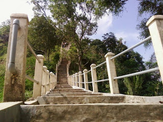
The location of this beach is far lower that the surrounding lands. You have to get down by the stairs in order to reach the beach and enjoy the panorama. While descending the stairs, you will be able to see the field, houses and mangrove vegetation on your left and right sides. Some people are seen carrying herbs for their cattle or taking care of the cattle in its stall.
In addition to the enchanting coastal panorama, Wediombo offers a unique tour experience, if not an extreme one, namely fishing from the height of the coral cliff. This kind of tour originating from the fishing habit of local people is popular with fishing hobbyists from Yogyakarta and Wonogiri. The main objective is, according to local people to YogYES, to catch big fish.
It is not easy to reach the fishing location at the top of the coral cliff. We have to walk eastwards through the shore; climbing steep and slippery cliff and sometimes the waves will hit us before arriving at the cliff that directly faces the deep ocean. For those who have been familiar with the route, it will take them one-hour walk.
The difficult way to the cliff, however, is paid well. Big fish are sometimes caught by the hobbyists. At least they will catch fish that local people name it panjo fish. The fish of which size is as big as man's arm are of two kinds, the cylindrical one that exist more during dry season and the flat one during the rainy season.
The baits are small fish that can even be collected at the seashore. We can use either fishing pole or fishnet to catch the small fish. It's cheap and easy, isn't it?
For those who do not dare to get to the top of the cliff, they might just buy the fish they the fishermen catch. They sell the panjo fish at IDR 3,000 one fish, or IDR 20,000 for a string of fish containing 5-6 fish. Some local people are willing to cook them for you if you wish. Otherwise, you can take them home as a gift for your family.
Cooked panjo fish are also available. Served with rice and condiment from chili pepper, fried Panjo fish is sold at IDR 7,000 only. The rice is served in the traditional container called bakul and the condiment is on traditional saucer called cobek. The portion is big enough for two persons. YogYES tried this menu in a warong located close to the parking area. Fried sea urchin that tastes like fried chicken is also available if you want to try.
At certain occasions, you can see Ngalangi ceremony that is held by local people. This ceremony takes place once in a year, just like the labuhan besar ceremony, of which objective is to express the gratitude to God for what have been granted and asking for good fortune for the future. The fortune is mainly good catches in sufficient quantity to fulfill daily needs.
The procession of the ceremony is unique; it begins by spreading gawar - the fishnet made from wawar tree. This kind of fishnet was used to catch fish before the present nylon fishnet. The gawar is spread out from Kedongkowok hill to the area of the rise and fall of the tides in order to trap the fish that are washed away by the waves and that cannot get back to the sea.
When seawater falls, the fish are collected. People are then busy cleaning and cooking the fish. Some of the fish are returned to the sea with some rice ans offerings. Most part of the dish is shared to the families. This ceremony is known as kenduri besar or great shared-meals as the form of local wisdom that fish are livelihood for all people.
In addition to Ngalangi ceremony, the enchantment of the beach can be enjoyed everyday. The entrance fee is only IDR 5,000 for two persons. If you want to spend the night and gather with some of your friends, you can use a small hut located close to the warongs alongside the beach. It is so refreshing to be in this beach.
Read More..
|


